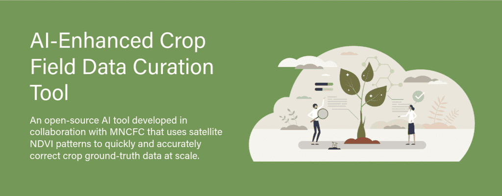
Problem
Manually validating crop data across millions of farms takes weeks—slowing down critical decisions in agriculture
Ground-truthing today is labor-intensive, time-consuming, and hard to scale. This leads to inaccurate yield estimates, delayed policies, and missed benefits for farmers.
Why is it important to solve this?
Timely and accurate crop insights power everything from farmer subsidies and food security planning to climate resilience. By open-sourcing this AI-based GT correction tool, we enable states, researchers, startups, and the broader agri-tech ecosystem to plug into a shared solution—driving faster, more transparent, and scalable outcomes in agriculture.
Our Solution
This helps detect errors like GPS drift or misclassified crops and suggests accurate corrections. By reducing manual work, the system enables faster, more reliable crop classification and supports timely decisions on subsidies, insurance, and planning. Built to integrate with Agri Stack, Krishi DSS is scalable, adaptable, and designed to support governments, researchers, and innovators in building data-driven agriculture solutions.
Who can use it
Primary End Users
GIS consultants and crop analysts
Access risk lists, view individual student profiles with predictors and observations, and implement classroom-level interventions.
Field surveyors validating crop data
Monitor school-wide dropout patterns, coordinate strategies, and oversee implementation of recommended actions.
Agri-tech developers integrating GT correction in platforms
Support schools across clusters by guiding teachers, verifying interventions (e.g., attendance follow-ups), and tracking school-level implementation.
Other System Users
Government Agencies
Ministry of Agriculture, state departments, crop insurance bodies
Policy Makers
Planning schemes, subsidies, MSPs, disaster relief, and market interventions
Researchers & Data Scientists
Working with validated crop data for analysis and innovation
Startups & Tech Ecosystem
Building AI-driven crop classification and decision-support tools
Key Features & Functionality
Faster Ground Truth Correction
Cuts down GT correction time from days to just a few hours
from the Noun Project
High Accuracy at Scale
Uses satellite NDVI patterns and machine learning to improve data quality with minimal human error
Cost Savings
Reduces dependency on manual GIS labour, freeing up resources for other critical tasks
Timely Decision-Making
Enables governments and agri-programs to act on real-time, reliable data for subsidies, insurance, and crop planning
Open and Extensible
The open-source model makes it easy for states, researchers, and startups to adapt, improve, and integrate into other platforms
Performance Indicators
>90%
Reduction in manual effort for GT correction (based on pilot runs at state scale)
High Precision Classification
High Precision Classification of crops like wheat and paddy, with scalable support for other major crops
Improved Coverage
Supports quicker GT correction across larger geographies without compromising accuracy
Faster Policy Turnaround
Leads to early subsidy disbursal and better resource allocation
User Feedback Loop
Continuous learning from on-ground validations to refine the AI model over time
Technical Architecture
Created by Prijun Koirala
from Noun Project
AI Models
Crop Classification Model
Learns from NDVI patterns, satellite imagery, and historical ground truth to classify crops accurately.
Anomaly Detection
Flags inconsistencies in field patterns or unusual growth behaviors.
Created by Vectplus
from the Noun Project
Data Pipelines
Satellite & Field Data Ingestion
Automated pull from Sentinel imagery and GT survey tools.
Preprocessing & Model Update
Automates cleaning, NDVI computation, and retraining workflows.
Prediction & Analytics Engine
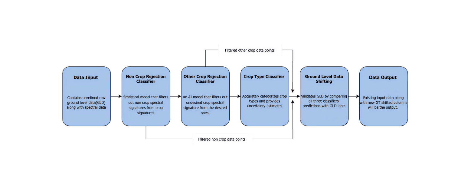
GT Correction Engine
Compares NDVI with GT to detect misclassification and GPS anomalies.
Correction Suggestions
Suggests fixes to improve GT accuracy in agri systems.
Integration
RESTful APIs
Provides endpoints for GT correction, crop labels, and validation scores.
System Integration
Plugs into Krishi DSS and other state/national agri-data platforms.
User Interfaces
GT Validation Dashboard
Visual interface to review GT points, NDVI overlays, and suggestions.
Approval Workflows
Allows analysts to validate or override AI-generated corrections.
Data Security & Storage
Cloud-Hosted & Role-Based Access
Runs on secure infrastructure; enables access control for field and admin users.
Role-Based Access
Granular control for field staff, admins, and analysts.
How to Use
Pre-requisties
(Languages, libraries, system requirements)
System Requirements
OS: Linux/macOS/Windows
Python 3.9
Conda (preferred for environment setup)
Internet connection (for model downloads & GEE access)
Google Earth Engine (GEE) account with access permissions
Libraries & Frameworks:
Core Libraries (from
requirements.txt):pandas,numpy,scikit-learn,rasterio,geopandas,earthengine-api, etc.
Data Requirements
Input
.CSVcontaining location geometries and crop metadata
INDIA_DISTRICTS.geojsonuploaded to GEE as an asset
Contribution Guidelines
We welcome contributions! Please read our contribution guidelines before submitting PRs
How to Contribute
Fork this repository
Create a feature branch (git checkout -b feature-feature name)
Make your changes and test thoroughly
Submit a pull request with clear documentation
Use Issues tab to report bugs or request new features
Opportunities for colloboration
We encourage contributions to
Developers to improve interface and labeling efficiency
ML researchers to test or extend the auto-tagging model
Agriculture teams to contribute labeled data and use cases
Contributors to improve metadata standards and documentation
Inner-Source Info
This project is licensed under the Apache License 2.0, a permissive inner-source license that allows commercial use, modification, distribution, and private use. It requires preserving copyright and license notices, grants contributors’ patent rights, and permits redistribution under different terms without mandating source code disclosure.
Repo URL / Public Access Link


Contributors
Team or Contributors
Sree Krishna
Associate ML Scientist
Gopika Gopan K
ML Scientist
Mohammad Salman
Group Product Manager
Contact Persons
Mohammad Salman
Group Product Manager
Email ID:
community.kiran@wadhwaniai.org
Acknowledgement
We would like to acknowledge the support and guidance provided by experts at Mahalanobis National Crop Forecast Center (MNCFC). Their domain expertise and insights have been invaluable in building models that can accurately predict crop types using satellite imagery. We would also like to thank the open source community for developing many of the Python libraries and tools that were crucial in building the models.
Wadhwani AI @ 2025. All rights reserved.